|
|
|
|
|
California's Lost Coast©By Sam Taylor
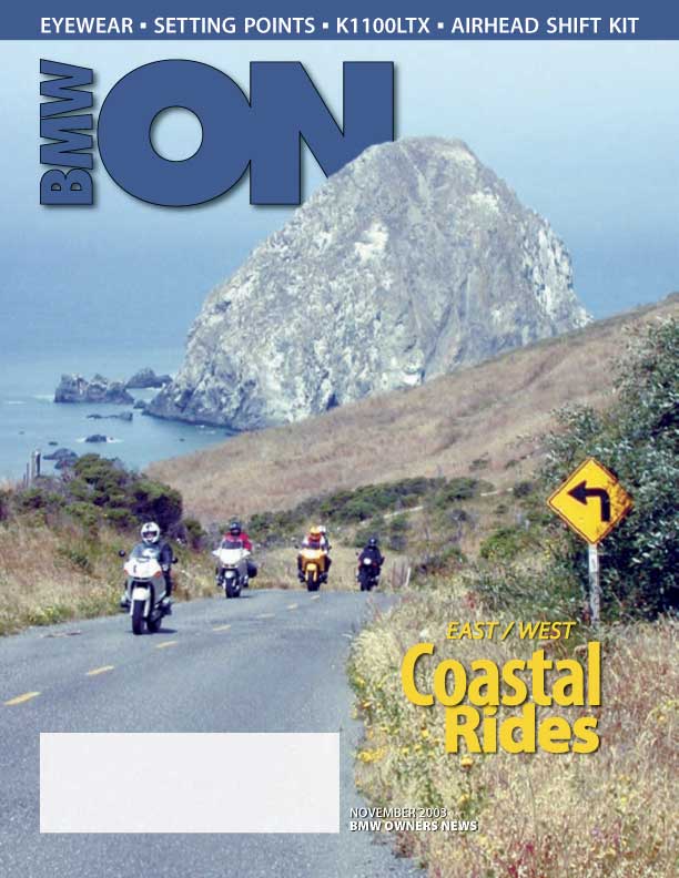
The name of this piece of pavement, thanks to the River it briefly follows, is the Mattole Road. The location is the somewhat notorious Lost Coast of California, 200 miles north of San Francisco, west of the Redwood Empire. The weather: usually foggy, occasionally spectacular. I was on the road with my buddies from the Montgomery Street Motorcycle Club on a 3-day, 2-night excursion to one of our favorite riding areas in the state. Our base was the Scotia Inn, the stately queen of the town of Scotia, about 20 miles south of the city of Eureka. Scotia itself is a small factory town surrounding the headquarters of Pacific Lumber, at one time the largest employer in this part of the state. Now the largest employer is the state itself, something to consider. With me were about 16 BMW riders mounted on everything from one /6 to 3 R1100RSs to innumerable GSs in 1100 and 1150 trim to several RTs, 3 in the newer 1150 style (a trend of which I am a proud part). Oh, there also was a VFR and a Ducati ST2—we really are a non-denominational club, despite the profusion of blue-white roundels. After an outstanding ride from the San Francisco Bay Area on Friday we were delighted to find that although the town of Scotia is light on facilities, the Inn itself is heavy in charm, amenities, and service. For the next 2 nights it provided a base of action, serving as it did all our lodging, dining, drinking, and poker-playing needs. On foggy Saturday we were presented with a choice: one group was going to head inland towards Trinity County on what we all knew to be some of the finest asphalt in the state (CA routes 36, 3, 299, 96 and everything in between). These folks believed the coast would be too cold, as it often is. The other group donned their electric vests (I know, this is California in July) and went to find the Lost Coast. Leaving at 9AM, we headed south toward the Avenue of The Giants, the “Blue Highway” that parallels US 101 and is popular with Redwood-awed tourists. At that hour, however, and coming from the north, there was very little traffic. It was a beautiful and, yes, awe-inspiring ride through the dissipating mists of the morning fog. Streams of sunlight coursed down upon us; the crisp air and perfect road conditions encouraging a good pace among the Giants. The Avenue eventually spills right into the Mattole Road at the confluence of the South and Middle Forks of the beautiful Eel River, bridges and viaducts, old and new, heading every which way above us. We began to head west, away from the Eel, and through grove after grove of giant redwoods often growing well into the pavement. At this point the group (almost) slammed into the back of a Ranger (fully empowered to issue traffic awards), who kindly decided to give us an escort for the next 5 miles or so. Despite the twitching throttle hands, I think we have him to thank for helping us slow and smell the roses. The road itself became demanding, rising up and over several mountain ranges. Although popular with all motorcyclists, BMW riders found themselves delighted if they had a Telelever front suspension, as the twisty turns and occasional animal or gravel patch insist on a good deal of on-off throttle control, and fork dive is not your friend. In other words, the /6 fell behind (but in great style, of course). Also, it was interesting to watch the GSs and the RTs battle it out. Here you have a group with fairly similar riding skills testing these bikes side-by-side on what would normally be called a perfect GS road, but the newer 1150 RTs had some of the GSers impressed as they often claimed front position. As usual the RSs kept up due to the skill of their pilots, but I think they had to work a bit harder. The weather by now was beautiful: sunny and warm, but not too hot. As we crested range after range, the view was one of gorgeous isolation, nary a sign of humanity to be seen in any direction. Off in the distance, to the west, was a thin purple line that any coastal Californian knows means dense fog, but it was many miles away. Suddenly, we were presented with a quick descent, and a river valley opened before us: the Mattole. We crossed a wooden-decked bridge into the town of Honeydew. Honeydew sports a general store and…some people who hang around it. That’s about it, although if you really want to get away from it all, and you like your dirt roads, from here you can head south towards Shelter Cove, the largest settlement in the Lost Coast area. It actually has a small airport…it needs it. After some refreshment, we continued northerly through some sparsely populated farm and ranch lands, soon reaching the other town on our itinerary, Petrolia. Petrolia is so-named because at one time oil was discovered here, which is almost impossible to comprehend if you have ever visited the area. Not only is Petrolia an unlikely-looking oil producing area—one usually thinks of the Texas plains or offshore platforms—anyone who thought they could transport the product from Petrolia to the real world was very ambitious. On the other hand, the men who discovered the black gold were from eastern Pennsylvania, also rugged country and, at the time, somewhat difficult from which to get oil distributed. Not as difficult as Petrolia, apparently, because the boom there never occurred. We proceeded through more rolling farmland, then topped a ridge and saw and descended toward the Pacific, a majestic and sudden change of scenery. The fog was well offshore, a rarity, for usually here at Cape Mendocino it is pervasively cold, damp, and gray. That day we could see the impressive array of dunes that shelter the road (and cows) from the beach for miles. Soon—too soon on such a beautiful day—we turned inland again and began our climb back over the mountains. Sure enough, as we headed north, the fog reappeared. We dove into it, avoiding deer, cows, and the occasional bicyclist that let us know we were approaching civilization. We descended then into the 19th century. Ferndale was settled in the 1800s by Easterners who brought with them their love for Victorian architecture. They built this quaint little town as a center for the farming and dairy industries that thrived here where the Van Duzen River, feeding the meandering Eel, creates delta-like plains. Thanks to them it has the charm, thanks to its current citizens it’s been maintained and enhanced. Nowadays it is the home of artists, people of the land, and commuters from Eureka. Recently, the town was depicted in the film “The Majestyk” as a late 1940’s all-American city, but rather than rent the DVD, I think you ought to ride there and see for yourself. Tourists invariably enjoy Ferndale whether it is sunny or not. “Not” is the norm, as it was the day we were there. Nevertheless, we enjoyed a fine lunch at Curley’s, located in the historic Ferndale Inn. Here you can hitch your bikes up to old hitching posts and take a stroll around town, stopping by the “Westernmost Saloon in the Continental US”, another reminder of how far this part of California juts out into the pacific. Alternatively, you can test the heat resistance of an Aerostich suit. Simply lay it over your exhaust headers and go have lunch and a stroll. You’ll find out just what happens, as did one of our hapless riders. That same fellow had previously had a run-in with a large 16 penny nail, and got to discover just how many CO2 cartridges it takes to get back on the road. An old word to the wise—beef up the BMW tire patch kit with a CO2 gun and extra cartridges, or get a newer kit entirely. You’ll thank yourself someday. We scattered for the short ride back to Scotia and returned to the warmth and hospitality of our Inn. The ride, including lunch and a break in Honeydew, had taken about 4 hours even though we had ridden the 110 miles or so at a brisk pace. It was just that when it’s found, the Lost Coast is such a nice place to be. |
|

 Somewhere in the fog of Humboldt County there exists a Road, one small, often single-lane Road, that can take a motorcyclist from the tallest Redwood forest to a nearly barren, windswept beach –the farthest west anyone can ride in the continental US--and then back to a Victorian village. On the way our motorcyclist will visit two small, improbable towns: one a former oil patch, the other perhaps the center for other, less-discussed, agricultural pursuits.